Severe storms continue to produce heavy rain, lightning and flooding
across parts of US
[April 17, 2026]
By COREY WILLIAMS and ED WHITE
Storms barreling across the heart of the United States continued to
threaten rain and pose flooding risks Thursday after causing at least
one death when a man apparently was struck by lightning in Wisconsin.
Police in Waukesha, west of Milwaukee, said the “area was experiencing
heavy rainfall accompanied by significant thunder and lightning” when
someone reported seeing the man on the ground Wednesday evening.
“Preliminary information indicates the individual was struck by
lightning while walking through the parking lot during the storm,”
police said.
A weather pattern combining very moist air with a strong jet stream has
stretched from as far south as central Texas into the Midwest and east
across the Great Lakes. From Monday through Wednesday, the National
Weather Service received more than 1,100 reports of large hail, winds
above 60 mph (96 kph) and tornadoes as part of the storm system, said
Bill Bunting, a meteorologist with the weather service’s Storm
Prediction Center.
Teams were out Thursday surveying damage to determine the exact number
of tornadoes, Bunting said.
The storms have rumbled across a number of states for the better part of
this week and could continue into the early weekend.
“There's been a tremendous amount of lightning with these storms over
the last few days,” said Mark Gehring, a meteorologist with the weather
service in Milwaukee.

“We've had the temperature and humidity of summer and it's lasting an
entire week — in mid-April,” he added. “In addition to a very stormy
pattern, nearly every day we're having heavy rain. We've had tornadoes
nearly every day, very large hail.”
Five tornadoes have been confirmed across southern and central
Wisconsin, but the number could rise after surveys, Gehring said.
In addition to lightning, hail and tornadoes, the storms have brought
rain — lots of it, with scores of flood warnings and flood watches
issued by the weather service over multiple states.
Crews were hurriedly pumping water from a dam in Cheboygan, Michigan,
this week, even removing floodgates to relieve pressure. Some residents
were told to prepare a “go bag” containing important personal items,
though Cheboygan County Sheriff Todd Ross said the number of people in
the zone was relatively small.
“We are in crisis mode now,” said Michigan Gov. Gretchen Whitmer, who
declared emergencies in dozens of counties because of flooding and other
weather woes.
In northern Michigan, Bellaire, population 1,000, said its wastewater
treatment system was being overwhelmed, forcing the release of partially
treated waste into area swamps. The village urged residents to reduce
home water use.
[to top of second column]
|

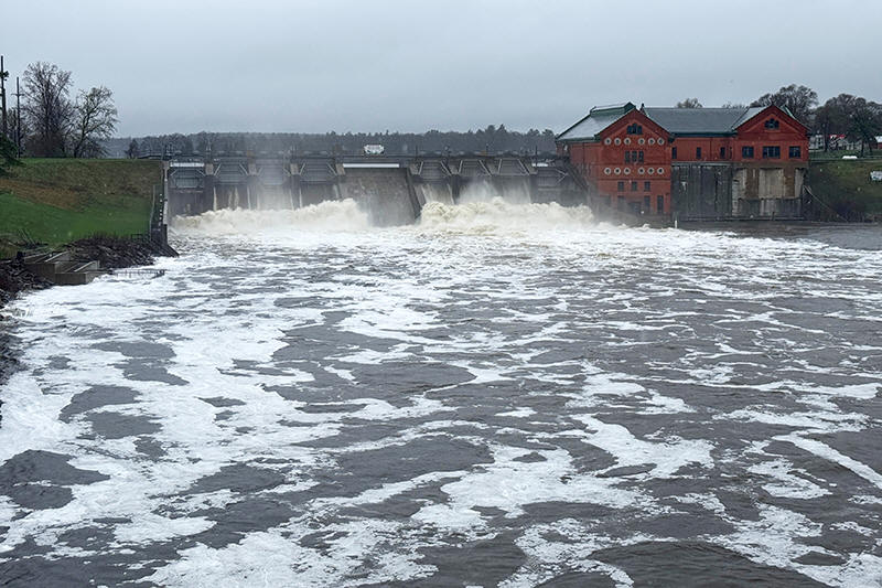
This photo provided by Bruce Carlson shows water rushing through the
Croton Dam on Thursday, April 16, 2026, in Croton Township, Mich.
(Bruce Carlson via AP)

Carl Johnson, 59, has a home on the rapidly rising Muskegon River in
western Michigan. He went on Facebook to tell people that his boats
were ready if someone needed help. People living in the river’s
flood plain below the Croton Dam in Newaygo County were ordered to
evacuate.
“It’s out of the banks everywhere. It’s really bad,” Johnson said of
the river.
Bruce Carlson, who lives behind the Croton Dam, said the roar of the
water was “deafening.” Consumers Energy, which owns the dam, said it
was structurally sound.
The Wisconsin River is at major flood stage in Portage, Wisconsin,
and is forecast to reach or surpass the 20.7-foot (6.3-meter) record
sometime Friday morning, meteorologist Gehring said.
“Right now, it's at 19.9 feet (6 meters), not that far off,” he
said. “In Portage, there's a large area of low-land flooding. Many
roads are flooded. There's a levee there. It's important that the
levee holds.”
Wisconsin Gov. Tony Evers declared a state of emergency earlier this
week.
Cars were stranded Wednesday night in high floodwater on a highway
in Milwaukee and the Milwaukee County Sheriff’s Office posted online
to urge people not to drive in southeast Wisconsin.
But at least in Wisconsin, a respite could be near.
“We have one more severe, heavy rain event coming this way before we
get a good break,” Gehring said. “That's going to be on Friday
evening. That's going to be the last gasp of severe rain.”
Bunting said the storm system will continue to move north and east
and likely will take three to four days to finally move off the U.S.
east coast.
“Probably, the most concerning day in terms of intense thunderstorm
potential and tornadoes is Friday, extending from northern Oklahoma
into central Wisconsin and far eastern Illinois,” he said.
___
Williams reported from West Bloomfield, Michigan. White reported
from Detroit.
All contents © copyright 2026 Associated Press. All rights reserved
 |